 Sweet flower! Of all that bloom by hill or glen Through smiling Kent, there’s none I love like thee For thour’st the truest type of true born men
Hardy unbought, untamable and free...”
Sweet flower! Of all that bloom by hill or glen Through smiling Kent, there’s none I love like thee For thour’st the truest type of true born men
Hardy unbought, untamable and free...”
OCND Conservation Trainee – Halfway Point
I am now well over halfway through my traineeship here with OCND and despite lockdown, the time has zoomed by and I have got lots done! Here is a summary below of some of the interesting things I have managed to get up to…
Condition Assessments
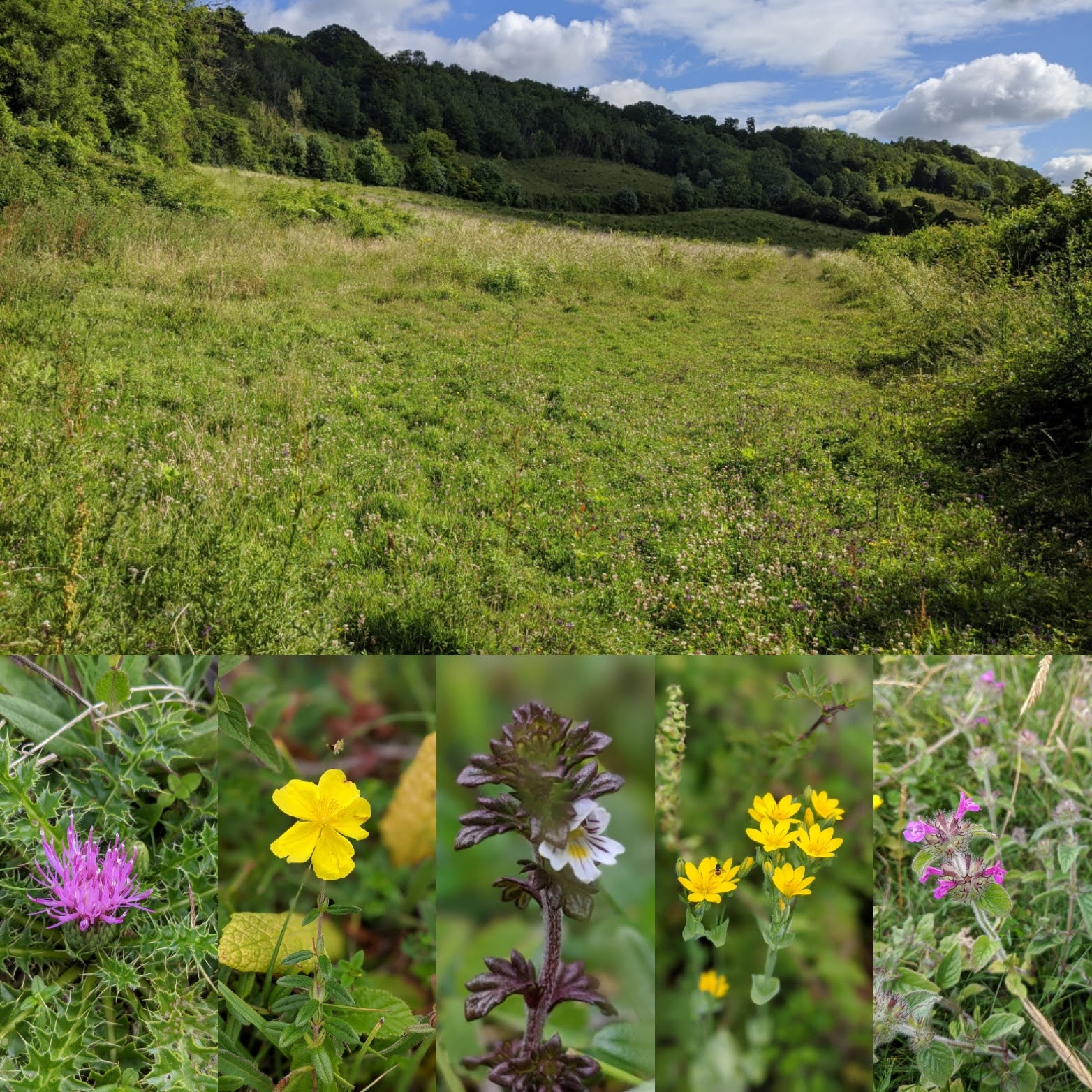
I have been busy getting to grips with the Condition Assessment of our chalk grassland sites and uploading previous years data onto spreadsheets. On the back of that I created a database on Google Docs to collect this year’s data on. I did it on Google so that it was accessible across our surveying tablets and reduced the need to have paper ones and then upload later.
Once it was safe to do so, we started to go out surveying, identifying chalk grassland plant species across our project sites. I loved seeing all the changes over the short period of time (the difference between the early and late flowering species). My favourite site was Wrotham Water as it is a SSSI with plenty of potential, a huge range of chalk grassland plants, but in need of some TLC. Hopefully, the funding from the project will help with the restoration of this amazing habitat.
Hedgerow Surveying
As well as surveying chalk grassland, I have also been surveying hedgerows in project area to help with management of the hedges and improving them for wildlife and biodiversity. Whereas the Condition Assessment is a rapid assessment, hedgerow surveying is very details. For me it has been a steeper learning curve understanding the hedgerow survey as I have not had to identify trees and shrub species often in my previous experiences. I have enjoyed learning little tricks for identifying these species though, such as with dogwood, their leaves are the only ones to have stringy bits that hold the leaf together if carefully pulled apart.

Google Maps
I have updated and created Google Maps for the website. These are a practical way of displaying the sites for the public to see and learn about what the project is funding. For me, it has been a useful exercise, especially during lock down where I could not get out to visit the sites myself. I have learnt geographically where the sites are and what we are doing there, which has all helped with seeing the bigger picture of the project. If you want to see the maps and find out for yourself what we are up, in the menu at the top, select Maps.
GIS Maps
Since my first month, GIS has still been a huge part of my role. I have continued to create a range of maps, from ones to show the outline of work to be funded when a landowner joins the project, to creating my own flood risk layer from data from the Environment Agency. I used the flood risk layer to identify hedgerows in flood risk areas which, if they were maintained and managed, could provide vital flood defence to a very fragile landscape.
30 Days Wild
Back in June, I was responsible for our 30 Dyas Wild campaign. Organised by The Wildlife Trust, 30 Days Wild is about doing something every day throughout June that connects you to nature. Across all our social media, I posted what we were getting up to as a team every day. My favourite day involved walking a butterfly transect and improving my butterfly identification skills.

At the end of the month, I produced a video showing all the activities that we got up to. You can see it here on our Facebook page https://www.facebook.com/watch/?v=287512845636052&extid=jcCDVbsShFudGkXe . I love doing 30 Days Wild as it really helps me personally to reconnect and remember all the good things about spending time in nature.
Walking Festival and StoryMaps
Our original Walking Festival this year was cancelled due to the Covid pandemic. To replace this and help people reconnect with nature coming out of lockdown, we are turning the festival virtual. We hope to achieve this by using GoPro footage shot by our wonderful volunteers, editing the videos, and creating maps and detailing routes on StoryMaps. This is an exciting part of the project and I hope it gets people out and about to enjoy our lovely project area. Watch this space!
I really cannot believe that I am over halfway through the traineeship and that I only have a few months left. It is still an incredible experience and I am loving the variety of the role. The other good thing to come out of the traineeship is that it has already given me the experience I need to get a Graduate job with the KCC Ecological Advice Service as a Graduate Biodiversity Officer. I will continue with the project until December and then go full time in my new role. The traineeship has fulfilled its role in getting the trainee into the conservation sector, and I could not be more grateful!